
.jpg?1677071824)
Next Generations of ORBCOMM SCU Terminals
1. ORBCOMM OG2-GPS Modem – This tracking unit delivers connectivity over the LEO ORBCOMM VHF satellite network for transportation maritime, land (road and rail) and aeronautical, heavy equipment, agricultural and other markets (see Figure 8a). It measures 40 × 70 x 0.5 mm and has a Mini PCI Express 52-pin edge connector with a 0.8 mm pitch. Its input voltage is 2.8 to 15 VDC. Input current in transmit mode is 1.6 A, GPS draws 35 mA and receive mode uses 70 mA.
ORBCOMM's OG2 and OGi satellite modems share the same electrical and application interfaces. This allows for seamless plug-and-play satellite connectivity over either network with no additional time or resources spent on development and integration. The OG2 satellite modem supports low power consumption for improved longevity in battery-powered applications, and its modems do not require a fixed line of sight with the satellites. The GPS version includes a built-in accelerometer and is well-suited for use in mountainous terrain and dense urban areas.
2. ORBCOMM GT 1100 Modem – This unit enables full control of mobile assets and containers (see Figure 8b). It allows complete visibility and control of fixed and mobile assets. As part of a comprehensive solution that includes sensor technology, powerful Web and mobile applications and reliable cellular and satellite connectivity options, the GT 1100 helps businesses optimize operational efficiencies and reduce costs. It is available as a cellular or dual-mode satellite-cellular version powered by solar rechargeable batteries for low power consumption and long service life in the field. It operates autonomously and requires minimum maintenance, no battery changes and can externally interface to a GPS receiver.13,14
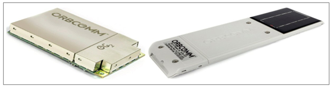
Figure 8 OG2 and GT 1100 SCU terminals: OG2-GPS Modem (a) and GT 1100 Modem (b).13, 14
3. ORBCOMM MT 5000 Modem – This is reliable small craft and shipborne tracking device for safety, security and compliance that ensures secure, consistent and reliable M2M vessel fleet location (see Figure 9a). The MT 5000 is a class B transmitter, broadcasting Radio – AIS (R-AIS) messages to nearby vessels and coastal AIS stations, along with ORBCOMM’s S-AIS network. This unique combination delivers more reliable and comprehensive fleet location data. It brings the power of reliable tracking to smaller vessels.
It uses rechargeable lithium manganese batteries with very low self-discharge. It can be charged from 9 to 32 V DC or by means of universal 12 V AC/DC adapter. It operates at 4 VHF AIS frequencies, two for R-AIS and two for S-AIS with a minimum 2 to 3 W EIRP. It also uses 50 Global Navigation Satellite System (GNSS) channels for GPS satellite-based augmentation systems, such as WAAS, EGNOS and MSAS and non-augmented GNSS networks such as GPS, GLONASS, Galileo and BeiDou.
4. ORBCOMM GT 700 Modem – This unit provides reliable satellite-based asset detection, tracking and security in the transportation and distribution, oil and gas and other industrial markets (see Figure 9b). It supports a security cable that wraps around container-locking bars or other latching mechanisms to ensure cargo security. The device delivers alarms when the cable seal is broken or disconnected to help deter theft.
It uses a lithium internal (primary battery) that lasts five years at two messages per day. It provides simplex (one way) transmission via circular polarization division multiplexing and adaptive transmission modulation over the LEO satellite constellation and tracking with a GPS receiver operational to 1,000 knots (515 m/s) in service for ships and aircraft tracking as well.15,16

Figure 9 MT 5000 (a) and GT 700 (b) SCU terminals.15,16
Satellite Communication, Tracking and Monitoring Terminals
To enhance safety and security in transportation systems it is necessary to implement satellite asset tracking (SAT) for all mobile solutions, especially for ships and small craft via two-way data transfer devices in portable sizes. With their reduced power consumption of main, solar or battery power, these portable units are an effective way of remotely collecting position, velocity and time (PVT) data from ships, containers, vehicles, locomotives with wagons and small craft for transmission to the tracking control station (TCS). In this article only two ORBCOMM SAT and fleet management terminals will be discussed, global transportation management and heavy equipment management terminals.
1. ORBCOMM PT 7000 Modem – This unit integrates cellular and optional satellite trackers in cases where monitoring units are outside of ORBCOMM satellite coverage (see Figure 10a). It provides comprehensive monitoring and control for heavy equipment and vehicles used in the construction, mining, rail and utility industries. As part of a comprehensive telematics solution that includes sensors, connectivity and applications, the PT 7000, available as a cellular or dual-mode satellite-cellular version, gives customers complete visibility and control of their heavy equipment fleet and allows them to manage their operations more effectively by enabling access to real-time data and analytics.
It receives asset status updates and engine alerts, configures reporting intervals, responds to requests for asset positions and more. A satellite connectivity option is available for critical applications to ensure alarm delivery and response. It also receives real-time alarms when specific conditions are detected or thresholds are exceeded and an asset has been turned on, an engine reading has exceeded a threshold, an asset has entered or exited a geofence, low oil pressure is detected and more. It provides accurate status and position information along with key operational metrics so all users can proactively manage their fleets anywhere in the world.
By leveraging equipment utilization and maintenance reports, customers know where their equipment is, if it is productive or needs maintenance, if oil pressure is within limits and how it is being used to better allocate resources and improve operational efficiency. In addition, equipment alerts including unauthorized movement or out-of-spec sensor readings such as loss of oil pressure or high coolant temperature can be quickly communicated to a mobile device to ensure a timely response.
Necessary time to provide alert delivery is 30 seconds and poll response time is 2 to 3 minutes. The terminal provides reporting interval position, motion start/stop, condition-based fault codes, engine/idle hours, fuel consumption, battery voltage, antenna connect/disconnect and pre-defined event triggers. It interfaces four digital inputs, two digital outputs, two pull-up, two pull-down, four analog inputs, 4 1(/2) CAN/J1939 bus ports, 2(/1) Serial ports, LED and Bluetooth low energy.17,18
2. Global Transportation Management RT-6000 Terminal – This terminal can be used for integrated GPS with dual-mode cellular and satellite tracking and management and has many interfaces for monitoring sensors (see Figure 10b). The ruggedized RT 6000+ provides visibility, control and decision rules to dispatch and operations centers, maintenance organizations and operational managers of transportation companies worldwide.
Using a unique direct interface to any refrigerated asset it provides comprehensive temperature and fuel management, maintenance, logistical and management applications services to revolutionize refrigerated transportation operations (see Figure 11). Transport customers can make immediate, important decisions about their reefers or any other vehicles, allowing for smarter investments in transportation system operations, logistics and immediate savings as well as improved end-to-end operations. With two-way interfaces, this solution delivers the most effective refrigeration and fleet management tools in the industry for maximum compliance, efficiency and return-on-investment.2,10
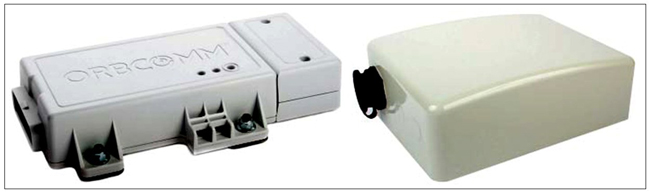
Figure 10 Heavy equipment and transport management: PT 7000 Modem (a) and RT-6000 Terminal (b).17,18
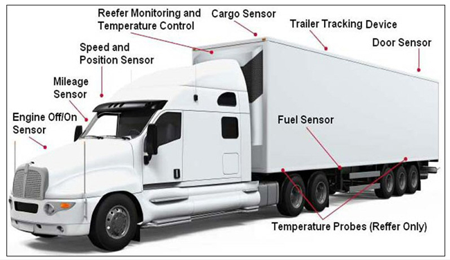
Figure 11 Tracking sensors onboard a truck.2
Maritime Satellite AIS (S-AIS) Terminals
The ORBCOMM LEO operator provides a new and more reliable satellite automatic identification system (S-AIS) via VHF frequencies for oceangoing ships with onboard broadcast systems. Ship identification, position and other critical data received from the GES can be used to assist in navigation and improve maritime safety and security at sea. In a similar way, the S-AIS system can be used for aeronautical applications so that aircraft position and other critical data can be used to assist in-flight operations and improve aeronautical safety.
The most current terrestrial-based Radio AIS (R-AIS) system implemented by the International Maritime Organization provides only VHF limited coverage nearby shorelines; it is not able to provide global coverage. The ORBCOMM satellite system overcomes this due to a fully Satellite AIS (S-AIS) data service that can monitor maritime vessels well beyond coastal regions and the horizon in a cost effective and timely fashion and send this data via GES to the Coastal Surveillance Center or TCS.
An AIS receiver using satellites can extend the VHF range of R-AIS systems considerably and makes it easier to monitor ship ocean navigation and fishing areas. ORBCOMM was the first commercial satellite network to begin operations with S-AIS data service. In 2008, ORBCOMM launched the first LEO satellites specially equipped with the capability to collect AIS data with plans to include these capabilities on all future satellites for ongoing support of global safety and security initiatives.
Figure 12 shows the space and ground configuration of S-AIS integrated with R-AIS. In fact, all ships receive GNSS PVT signals from the US GPS (1) or Russian GLONASS (2), then ships out of R-AIS coverage send via service link (3) PVT data to an AIS satellite. This data is transmitted via a feeder link to the GES (gateway) terminal (4).
All ships inside of R-AIS coverage send GNSS PVT data to the R-AIS base station (BS) via radio link (5), while all ships have AIS data communication via inter-ship links (6). Received AIS data from the GES and AIS BS is forwarded via terrestrial links (7) to the SCS terminal for processing. In this way, AIS data with positions of all ships in a certain sailing region can be displayed on a radar-like screen and used for collision avoidance.1,2
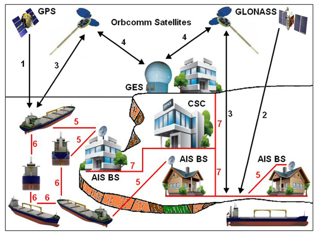
Figure 12 ORBCOMM Satellite AIS (S-AIS).2
CONCLUSION
The versatile ORBCOMM products and Little LEO satellite constellation support multiple modes of communication, leveraging extensive experience to provide a broad portfolio of satellite, cellular and dual-mode IoT connectivity. The platform’s capacity has been expanded exponentially to process more than 100,000 messages per second, which is an increase of over 1000x in message throughput over legacy systems. With the ORBCOMM satellite network, it is possible to provide increased processing capability. Customers can continue to expand their deployments, access a higher level of visibility and enable more sophisticated solutions in a 5G sensor-enabled IoT ecosystem integrated with satellite solutions.
References
- Mobile Satellite Communication Systems, CNS Systems, 2019.
- D. S. Ilcev, Global Mobile Satellite Communications for Maritime, Land and Aeronautical Applications, Vol. 2, Springer, Boston, MA, 2017.
- S. Reid, T. Maclay, D. Brickerd, R. Burdett, M. Lord and T. Rudd, ORBCOMM System Overview, ORBCOMM LLC, 2010.
- A. Jamalipour, Low Earth Orbit Satellites (LEO) for Personal Communication Networks, Artech House, 1998.
- V. Lloyd, ORBCOMM Constellation, Lloyd's Satellite Constellations, University of Surrey, 2006.
- A. Loretta A., AIS: New OG2 Satellites Enable Near Real-Time Vessel Monitoring, ORBCOMM Inc., 2016.
- R. E. Sheriff and Y. F. Hu, Mobile Satellite Communication Networks, Wiley, 2001.
- F. Kuester, “Connecting the World’s Assets – A Portrait of ORBCOMM,” Combined Transport Magazine, June 2016.
- I Marijan, O. Olugbara and S. D. Ilčev, “Introduction to the Global Ship Tracking System via Mobile Satellite Constellations,” The 1st International Conference on Maritime Education and Development, Conference Proceedings Book, 2021, pp. 93-106.
- Orbcomm System Overview, ORBCOMM LLC, 2008.
- Stellar DS300 Data Sheet, Stellar Satellite Communications Ltd., Web: http://www.csdelectronica.com/joomlacsd/attachments/article/91/DS300DS.pdf.
- Q4000 Multi-Network Communications Device, Quake Global, Web: https://www.quakeglobal.com/products/q4000.
- OG2 and OGi Satellite Modems for OEM Systems Integrators, ORBCOMM LLC, Web: https://www.orbcomm.com/PDF/datasheet/OG2-OG-ISAT-Satellite-Modems.pdf.
- W. Leavitt, “ORBCOMM Unveils Solar-Powered Tracking Device,” FleetOwner, October 2013, Web; https://www.fleetowner.com/technology/article/21688294/orbcomm-unveils-solarpowered-tracking-device.
- Hardware Data Sheet, MT 5000, Reliable small craft tracking for safety, security and compliance, ORBCOMM, Web: https://vmsmea.com/wp-content/uploads/2021/09/MT-5000_letter_Eng.pdf.
- GT 700, Singapore Technologies Group, Web: https://www.singtechgp.com/telematics/devices/orbcomm/.
- PT-7000 Rugged Telematics, ORBCOMM LLC, Web: https://www.orbcomm.com/en/solutions/heavy-equipment/hardware/pt-7000.
- RT 6000+ Global Transportation Management Systems, Industry Leading Tracking and Monitoring Solutions for Refrigerated Assetts, ORBCOMM LLC, Web: https://www.orbcomm.com/PDF/datasheet/RT-6000-Reefer-Tracking.pdf.